TRAIL ALERT: Unfortunately, Motu Road has a major slip. The road is impassable to all traffic, bikes included. The slip is on Papamoa hill, about 4km north of the top of Pakihi Track. There is currently no Motu Road access from the Opotiki coast to Motu village; and no Motu Road access from Opotiki coast to the top of Pakihi Track. To get from Opotiki to Motu village or to the top of Pakihi Track you must go via SH2 Waioweka gorge to Matawai, then the southern end of Motu Road. You can ride both ends of Motu Road—just not all the way through. The closure will apply through summer and potentially longer.
Made up of three wildly different rides, the Motu Trails Great Ride has something for everyone – from easy rides along the stunning Pacific coast to classic singletrack following a historic byway through bushy backcountry.
This trio of trails is a wonderful to way to get to know this special corner of the North Island, centered on the town of Ōpōtiki and the villages of Motu and Matawai. The leisurely Dunes Trail takes in coastal scenery with opportunities for seaside picnics and swimming. It leads to the Motu Road, a historic byway venturing inland to the remote settlements of Motu and Matawai. Halfway along the Motu Road is the start of the legendary Pākihi Track, which winds back towards Ōpōtiki on singletrack through fabulous forest and a hidden valley – an absolute New Zealand MTB classic for advanced riders.
The three trails can be linked together for an unforgettable 91km loop or split and spliced to make rides suitable for most ages and abilities. The Motu Trails also provide an important link for road tourers and bikepackers heading through Tairāwhiti Gisborne via the tranquil Rere Falls Trail.
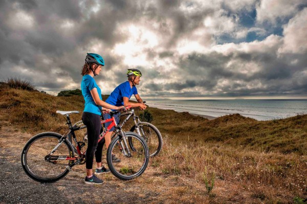
Views for miles on the Dunes Trail (Mandy Hague).
- ocean, forest & mountain panoramas
- challenging backcountry singletrack
- fascinating Māori & early settler history
- swimming & picnics on stunning beaches
- fun, family riding the Dunes Trail
- virgin forest & unique coastal habitats
- authentic heartland hospitality
- photogenic Māori carved poles (markers)
The trail is split into three separate rides that can be completed individually or as a 91km loop. The whole trail can be completed in 2–3 days or broken up easily into shorter adventures, with local shuttles available for one-way rides.
The Dunes Trail can be ridden as an easy there and back up to 20km long, depending on where you turn back. Unless completing the whole loop or overnighting on the trails, the Motu Road and Pākihi Track are best tackled with transport for drop-offs or pick-ups.
A great, two-day option for reasonably fit riders is to cycle from Ōpōtiki to Motu (61km) on the first day where you can stay overnight, and then head back up the Motu Road before riding down the Pākihi Track back to Ōpōtiki (61km).
Fit riders have been known to knock off the whole 91km loop in one day, although it’s a pretty big undertaking!
Dunes Trail
20km return, Grade 2/easy, 1.5–3 hours
This easy trail is great for riders of all ages and abilities with a wide, smooth surface and a total elevation change of only 100m along its entire length (200m when ridden both ways).
It starts at the graceful Pakowhai ki Otutaopuku suspension bridge in Ōpōtiki’s Memorial Park Reserve. From here it undulates gently along for 10km along the sand dunes east of town, with epic ocean and East Cape views and plenty of opportunities for picknicking on empty beaches or going for a dip.
Jacksons Road, at the eastern end of the trail, marks the start of Motu Road Trail, although riders may wish to turn back at the 9km mark as the final roadside kilometre is largely unremarkable.
Bike hire is available from Ōpōtiki isite.
Motu Road Trail
67km, Grade 3/intermediate, 4–7 hours
The Motu Road is best suited to fit riders who aren’t afraid of hills. Riding in the direction from Jacksons Road (near the coast) to the settlement Motu, this route dishes up 1600m of climbing. It can be ridden in the other direction, of course, with the end-point of Matawai already 500m ASL so there’s more downhill than up. Either way, it’s a pretty big effort that shouldn’t be underestimated!
From Jackson Road, the trail follows a quiet country road, mostly surfaced in gravel, up and over a highpoint of 750m above sea level. Traffic is generally very light but riders should always be on the lookout for cars and the occasional logging truck, especially around corners.
From Jackson’s Road, the trail heads towards Matawai along the old coach road that formed part of the first through-road between the Eastern Bay of Plenty and Tairāwhiti Gisborne. It’s mostly gravel-road riding through lush farmland and the remote bush country of the Raukumara Ranges.
It’s 24km – including a solid 6km climb up Meremere Hill – to the pint-sized settlement of Toatoa.
Winding up through magnificent forest for another 14km riders reach the Pākihi Track junction, where the 91km-loop riders leave the Motu Road.
From there the road climbs steadily, with some well-earned views across ridges way back to the coast and Moutohora (Whale Island), before a satisfyingly long downhill into the pretty Motu Valley. There’s welcoming accommodation here at the Motu Community House in Motu village (meals can be booked). The scenic Motu Falls are a worthy detour 5km away.
A further 14km away on a quiet, slightly uphill, sealed road is Matawai, the inland end of this ride, and a popular spot for shuttle drop-offs and pick-ups.
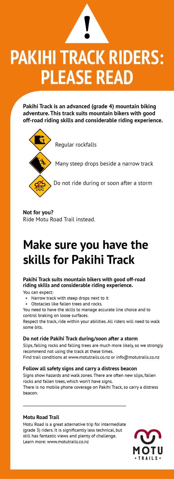
Pākihi Track
44km, Grade 4/advanced, 3–6 hours (20km singletrack, the remainder gravel and quiet sealed road).
Originally a pack track cut in the early 1900s, the Pākihi Track is now a wonderful 20km-long wilderness trail shared by bikers, runners and walkers.
The advanced track is strictly mountain bike territory and should only be attempted by experienced riders. Although not particularly technical, caution is advised – there are many drop-offs beside the track, while gravel, rocks and tree debris on the track can escalate the level of difficulty. The upper track also gets slippery after wet weather.
For the safety of other users, cyclists must start from the Motu Road end — no riding up from the Pākihi Road. Please keep your speed down, and walk any areas that are signed or of concern.
The first 11km section twists and turns through magical forest dominated by tawa, kāmahi, rimu and rewarewa, before reaching the Pākihi Hut around the half-way point. This is a great place to stop for lunch before heading onward.
The stunning lower section starts by crossing Pākihi Stream via an impressive 35m swing bridge, and then follows it all the way to the road end. Along the way keep an eye out for native birds including the kererū (wood pigeon), tui and fantails. If you are lucky, you may even see a kārearea (NZ falcon) or North Island robin. The cheeky North Island weka may also be heard calling out.
At the car park, riders can rest a while at the massive picnic table built by trail volunteers from an old bridge.
The last leg back to Ōpōtiki involves 9km on gravel road beside the river, followed by 10km on a quiet country road and 4km along the Otara stopbank trail back into town.
Note that the Rere Falls Trail (a 103km Heartland Ride) links Matawai with Tairāwhiti Gisborne via quiet, country roads and highway.
The scenic Rere Falls Trail Heartland Ride (Mead Norton Photography)
If you’re not sure what Motu Trails ride is right for you, ask at Ōpōtiki or Gisborne i-SITE, or the bike hire and shuttle operators in Ōpōtiki – they’re the ones in the know. Here are a couple of easy-to-arrange options taking in the top highlights.
Dunes Trail—Tirohanga (return)
18km, easy, 2–3 hours
Riding the Dunes Trail to Tirohanga and back is a great coastal ‘highlights’ package, complete with fabulous ocean panoramas, Hukutaia Beach picnic area, wetlands, and Tirohanga Beach itself. There are several places to access the beach, which is typically empty of people and strewn with interesting driftwood. Swimming may be enjoyed with due caution; note that the beach is unpatrolled. Bike hire is available from Ōpōtiki isite, close to the trail’s start in Ōpōtiki.
Motu Road (uphill assist)
67–75km, intermediate, 4–7 hours
Get a shuttle from Ōpōtiki up to Motu, or Matawai, or most commonly, the hill above Motu. You’re now set up for a pretty awesome roll along the gravel but not particularly technical Motu Road, followed by the cruisy Dunes Trail back to Opotiki – with way more downhill than up. Note that there two shelters along the way, but no shops until you reach the coast.
Pākihi Track (uphill assist)
44km, advanced, 3–6 hours
The most popular way to ride the Pākihi as a day-trip is to dodge the uphills by getting a shuttle from Ōpōtiki up to Motu, or Matawai, or most commonly, the hill above the track start. Shuttles run on demand with a minimum of four.
Make an early start so you can take time to enjoy the track, stopping at the hut for lunch and at the many other interesting spots along the way. The river can be fantastic for swimming.
Pakihi Track starts from high on the Motu Road, 17 kilometres from Motu and 38 kilometres from the Ōpōtiki coast. The track is one-way for cycling, from Motu Road to Pakihi Road.
There are no significant uphills and the surface is generally well-formed. However, in places, Pakihi Track is very narrow, with near-vertical drop-offs to the side. There are often fallen trees to lift your bike over. Especially on the lower section, in places, there is almost always rock debris on the track.
You need to have the skills to manage accurate line choice and to control braking on loose surfaces. Respect the track, ride within your abilities. All riders will need to walk some bits.
Pakihi is a back-country track in challenging terrain.
- You need sound bike skills and to take care. At all times, stay focused and your keep speed down. At any stage, if in doubt, get off and walk a section.
- You need to have the skills to manage accurate line choice and to control braking on loose surfaces.
- E-bikers and those with panniers, in several places, you must be able to lift or push your bike.
- Respect the track, ride within your abilities. All riders will need to walk some bits.
Do not ride Pakihi Track during/soon after a storm.
- Slips, falling rocks and falling trees are much more likely. We strongly recommend not using the track at these times. Find latest trail conditions or email Motu Trails
Follow all safety signs and carry a distress beacon
- Signs along the track show hazards and recommended walk zones.
- There are often new slips, fallen rocks and fallen trees, which won’t have signs.
- There is no mobile phone coverage on Pakihi Track, so carry a distress beacon (personal locator beacon).
If you do not have appropriate skills and experience for an advanced (grade 4) track, you may wish to consider riding the Motu Road Trail instead or do the Pakihi as a walk.
TRAIL STATUS & ALERTS
For current trail status and any alerts – such as temporary track closures and detours – check the trail website or Facebook page.
FITNESS & SKILLS
The Motu Trails are made up of a variety of grades and track surfaces suitable for a range of riding abilities – that’s part of their charm! Young, old and novice riders will particularly love the gravel surfaced, undulating Dunes Trail, while fitter riders and fans of singletrack will relish the Motu Road and Pākihi.
TYPE OF BIKE
While the Dunes Trail can be ridden on a hybrid or touring bike with knobbly tyres, a ship-shape mountain bike is recommended on the rougher and more remote Motu and Pākihi. (An increasing number of people are riding the Motu on wide-tyred gravel bikes.) Riders should ideally have basic mechanical skills and carry a tool kit on these two trails.
E-bikes are welcome on all the trails, although particular caution is advised for e-biking along the Pākihi: the bike’s weight may be an issue if you need to ride, lift or carry your bike over obstacles, however, previous e-bike riders have advised that their e-bike has performed well on this trail. Note also that battery capacity may be an issue on the long and arduous Motu Road.
The Dunes Trail has squeeze bars so those with drop bars, panniers or small bikes may need to dismount. The Pākihi is narrow in places, so if you have panniers you need to take extra care.
MAPS & NAVIGATION
Although the Motu Trails are well signposted, carrying the official Motu trail map will enhance the experience by pinpointing landmarks and assist with timings for shuttle pick-ups, etc. The map can be downloaded from the trail website.
You can also download the awesome Great Rides App to see where you are on the trail. It's free, works offline and has heaps of useful information, including trail descriptions and photos, trail services, food and accommodation.
WEATHER & RIDING SEASON
Both the Motu Road and Pākihi Track pass through remote, elevated terrain and it can be cold and wet even in summer. In the winter months, the inland sections can be cold and misty with occasional snow, but there are also plenty of spectacular riding days, too.
Regardless of the season and forecast, riders should always carry warm clothing and wet-weather gear, and consider taking a personal locator beacon (PLB), inexpensive to hire from Ōpōtiki and Gisborne i-SITEs.
FOOD & WATER
Dunes Trail riders will readily find refreshments in Ōpōtiki and a shop midway along the trail. Inland, there’s a shop in Matawai. Motu Road and Pākihi riders should, therefore, be self-sufficient and carry plenty of water and more than enough to eat.
CELLPHONE COVERAGE
Cellphone coverage is limited outside of Ōpōtiki, very patchy on the Motu Road and non-existent on the Pākihi Track.
TOILETS
As indicated on the trail map, there are toilets at each end of the Motu Road; midway and at the end of the Pākihi (basic; BYO toilet paper); and at the start and 3km mark of the Dunes Trail.
DOGS & HORSES
Dogs are allowed on the Dunes Trail but must be on leads for rider safety reasons, and to protect birdlife in the area.
On the Pakihi Track, a DOC permit is required for dogs and they must be be kiwi-aversion trained (contact DOC: 0800 275 362).
Horses are not allowed on the Dunes Trail and Pakihi Track.
TRAIL BROCHURE
The official trail brochure can be downloaded here.
Accommodation and other essential services are readily available in Ōpōtiki, Gisborne and Whakatāne. The Motu Trails, however, reach remote parts of the region with limited services. Advance planning and booking are therefore essential.
GETTING HERE
The main gateway town to the Motu Trails is Ōpōtiki in the Eastern Bay of Plenty. The closest regional airports are Whakatāne (which is not served by Air New Zealand) and Gisborne, Tauranga and Rotorua (which are). Auckland International Airport is around four hours' drive away.
Ōpōtiki also lies in various scenic driving routes including SH35 (Pacific Coast Highway) around East Cape to Gisborne. Rotorua’s thermal wonders and legendary Redwood Forest trails are also just 90 minutes away.
Nationwide Intercity buses link Bay of Plenty towns with destinations further afield, while smaller shuttle operators provide local services.
BIKE HIRE, TRANSPORT & TOURS
Bike hire, shuttles and luggage transfers are available from Ōpōtiki, with guided rides also possible for groups. Some bike hire and tour packages are also available from Gisborne. Fluctuating seasonal demand and remoteless of pick-up/drop-off points makes it essential to book these services well in advance.
ACCOMMODATION
Ōpōtiki has a wide range of accommodation both in town and around, all close to cafes, a supermarket and other visitor services.
Accommodation thins out considerably beyond Ōpōtiki. There are highly atmospheric options in Toatoa and Motu on the inland sections; their limited capacity makes it essential to book space in advance, the earlier the better if you plan to ride in peak season (December–March).
USEFUL LINKS
